
Welcome › Forums › Tropical Lows and Cyclones › Tropical Low 29U
Tagged: hi
- This topic has 4 replies, 2 voices, and was last updated 1 year, 3 months ago by
TommySmuct TommySmuct.

-
AuthorPosts
-
12 April 2025 at 01:16 #3471
 Nikko GilbertKeymaster
Headline:
Tropical cyclone expected to develop west of Darwin this weekend.
Areas affected:
Warning zone: None.
Watch zone: Cockatoo Island to Berkeley River Mouth.
Cancelled zones: None.
Details of Tropical Low 29U at 9:30 pm ACST:
Intensity: tropical low, sustained winds near the centre of 55 kilometres per hour with wind gusts to 85 kilometres per hour.
Location: within 55 kilometres of 9.8 degrees South, 129.1 degrees East , 350 kilometres north northwest of Darwin and 230 kilometres northwest of Pirlangimpi .
Movement: south southwest at 11 kilometres per hour .
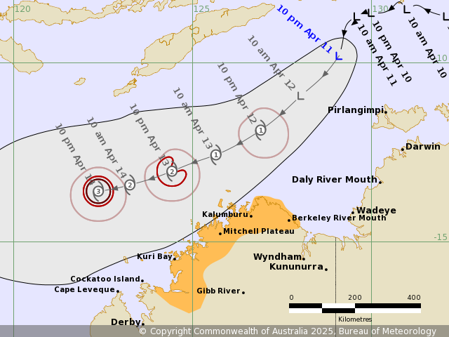
Tropical Low 29U is located to the northwest of Darwin and moving southwest, It will continue moving southwest across the Timor Sea on the weekend, but is expected to remain off the northern Kimberley coast.
29U is expected to develop into a tropical cyclone during Saturday with potential impacts for the Kimberley coast from late Saturday.
Hazards:
Gales with DAMAGING WIND GUSTS will possibly develop between Kuri Bay and Berkeley River Mouth, during Saturday evening. Gales with DAMAGING WIND GUSTS could also develop between Cockatoo Island and Kuri Bay during Sunday morning.
HEAVY RAINFALL may develop between Kuri Bay and Berkeley River Mouth, during Saturday evening. HEAVY RAINFALL may extend westward and persist between Cockatoo Island and Berkeley River Mouth during Sunday.
As the system moves past the Kimberley coast tides between Kuri Bay and Berkeley River Mouth may rise above the normal high tide mark, but the sea level should not exceed the highest tide of the year.
 12 April 2025 at 13:45 #3474Nikko GilbertKeymaster
Update to the lows stats.
Intensity: tropical low, sustained winds near the centre of 65 kilometres per hour with wind gusts to 95 kilometres per hour.
Location: within 55 kilometres of 11.3 degrees South, 127.4 degrees East , 340 kilometres north northeast of Kalumburu and 400 kilometres west northwest of Darwin .
Movement: southwest at 15 kilometres per hour .13 April 2025 at 01:25 #3475Nikko GilbertKeymasterDetails of Tropical Low 29U at 11:00 pm AWST:
Intensity: tropical low, sustained winds near the centre of 55 kilometres per hour with wind gusts to 85 kilometres per hour.
Location: within 55 kilometres of 11.6 degrees South, 126.1 degrees East , 305 kilometres north of Kalumburu and 465 kilometres north northeast of Kuri Bay .
Movement: west southwest at 12 kilometres per hour .Tropical Low 29U is located to the north of Kalumburu and is moving to the west southwest. It is expected to develop into a tropical cyclone during Sunday
17 April 2025 at 01:32 #3591Nikko GilbertKeymasterDetails of Severe Tropical Cyclone Errol 29U at 8:00 pm AWST:
Intensity: category 4, sustained winds near the centre of 175 kilometres per hour with wind gusts to 250 kilometres per hour.
Location: within 20 kilometres of 14.3 degrees South, 118.9 degrees East , 540 kilometres northwest of Broome and 620 kilometres west northwest of Kuri Bay .
Movement: slow moving .Severe Tropical Cyclone Errol has continued to intensify and has reached Category 4. Errol is currently slow moving, but is expected to start moving to the east southeast later tonight or during Thursday morning, taking it towards the west Kimberley coast.
Errol is expected to start weakening quickly during Thursday, decreasing to Category 2 during Friday, then to Category 1 early Saturday and below tropical cyclone strength as it nears the west Kimberley coast on Saturday.
Hazards:
Gales with DAMAGING WIND GUSTS may develop between Cockatoo Island and Beagle Bay during Friday, and may extend to Kuri Bay during Saturday morning. Gales with DAMAGING WIND GUSTS could extend southwards from Beagle Bay to Broome, only if the track shifts slightly south of its current forecast.DESTRUCTIVE WIND GUSTS of up to 130 kilometres per hour may develop between Cockatoo Island to Beagle Bay later Friday, but only if Errol moves faster than forecast.
Isolated HEAVY RAINFALL may develop between Kuri Bay and Broome during Friday and persist during Saturday morning as Errol moves closer to and crosses the west Kimberley coast.
Tides may rise above the normal high tide mark, but sea levels should not exceed the highest tide of the year.
30 April 2025 at 04:00 #3635TommySmuct TommySmuct
Participanthi
-
AuthorPosts

- You must be logged in to reply to this topic.