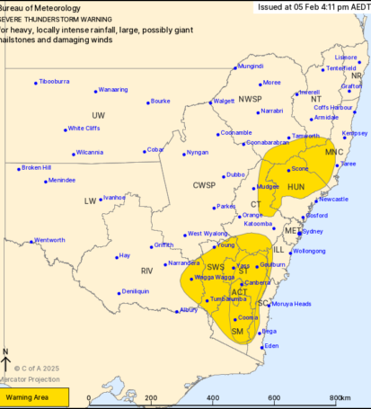
Severe Thunderstorm Warning
Issued by the Bureau of Meteorology
Date: 5 February 2024 | Time: 4:11 PM AEDT
Warning for: Heavy, locally intense rainfall, large, possibly giant hailstones and damaging winds
—
Areas Affected:
– HUN (Hunter Region)
– SWS (Southern Tablelands)
– ACT (Australian Capital Territory)
– SM (Southern Midlands)
– MNC (Mid North Coast)
– ILL (Illawarra)
—
Weather Conditions:
A severe thunderstorm has developed over the eastern parts of New South Wales, affecting the regions listed above. These storms are expected to produce heavy rainfall that may lead to flash flooding, as well as large hailstones, potentially reaching sizes classified as giant. Furthermore, damaging winds are likely, which could cause significant damage to property and vegetation.
Forecast Details:
– Heavy Rainfall: Rainfall rates may exceed 50mm per hour in some areas, leading to localised flooding. Residents are advised to monitor local water levels and heed any flood warnings.
– Hailstones: The storm is capable of producing large to giant hailstones, which can cause damage to vehicles, roofs, and crops. It is crucial to seek shelter indoors when storms approach.
– Damaging Winds: Wind gusts may reach up to 100 km/h, which can uproot trees, down power lines, and cause structural damage. Take precautions to secure loose items outdoors.
Safety Advice:
– Stay indoors and away from windows during the storm.
– If you are driving, seek shelter and wait for the storm to pass, as visibility may be significantly reduced.
– Check on vulnerable neighbours or family members to ensure their safety.
– Monitor updates from the Bureau of Meteorology and local authorities for the latest information.
Next Update:
This warning will be updated as conditions change or if new information becomes available. Stay tuned to this site or the Bureau of Meteorology website for real-time updates.
Stay safe, and take all necessary precautions to protect yourself and your property.