Thunderstorms
-What are they, what is required for them to form and what can cause them to be inhibited-
Thunderstorms are a form of severe weather that results in electrical discharges known as Lightning, other features commonly associated with thunderstorms are hail, damaging winds in the form of straight-line winds or tornadoes, torrential rainfall and in rare cases heavy snowfall when it’s a cold season thunderstorm. I will go through a basic explanation of what causes a Thunderstorm and what’s needed. My fellow storm nerds will know there are a lot of factors involved in the formation of storms however I will only be going through the layman explanation in this post.
So, there are 3 basic needs for a Thunderstorm to form
1. Instability in the atmosphere
2. Proper moisture profile
3. A trigger.
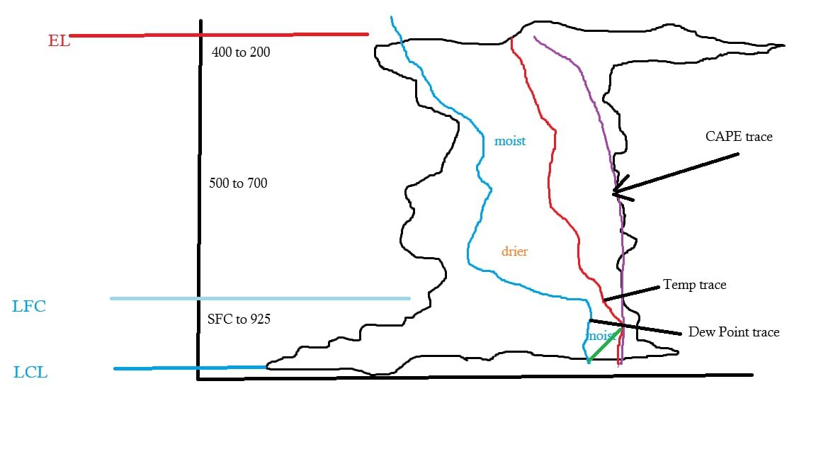
So, let’s start with the first need, atmospheric instability, Atmospheric instability is a condition where the atmosphere readily supports vertical air motion, causing a lifted air parcel to continue rising due to buoyancy if it remains warmer than its surroundings. This is measured commonly by the amount of CAPE (Convective Available Potential Energy), the higher the CAPE, the more instability and more energy available for Thunderstorm development. Lifted Index (LI) is a measure of the rate the parcel moves through the Atmosphere whilst cooling which accelerates the lapse rate.Next need is moisture. We need a high moisture content in the lower atmosphere. However there also needs to be areas of drier air in the mid-levels. This profile is often used to forecast hail but also the drier air helps the parcel of air to rise higher in the atmosphere.Next is the most important part, which without, you can have as much moisture and CAPE etc but without a trigger, you get nothing. A trigger commonly comes in the form of daytime heating, a dry line, cold front, orographic lifting and collision of air like on shore winds colliding with offshore winds (sea breeze boundary), anything that forces air to rise.
The most common triggers are either daytime heating or a sea breeze boundary. For the first one, as the land heats, air begins rising, in a process called convection, when the air rises it expands and cools, and when it reaches the dew point, it condenses forming clouds, if the convection is sustained, Thunderstorm clouds aka Cumulonimbus clouds form.
The other triggers have different effects, but the result is the same, it can cause convection. The collision of winds cause air to rise, a dry line will force the moist air ahead of it to rise, a cold front can do the same, causing the warmer air ahead of it to rise. Orographic lifting is the effect of air being forced up by mountains or large hills.
Another factor to consider is Wind shear, Wind shear determines what type of storm forms and for how long. Low Wind shear will produce a pulse storm that basically goes up and dies within a localised area and lasts about an hour. Stronger wind shear can produce longer lived storms and more severe conditions like damaging winds.
There is a lot more to this then I’ve stated but this is the most basic explanation. There are a lot more to the process then I have explained here. A forecaster or storm chaser, will also look at things like Lifted Convection Level (LCL), Equilibrium Level (EL) amongst many other things listed or shown on an Aerological Diagram aka Skew T.
Next, I’ll discuss what can cause a storm to fail in forming. What I’ve explained so far is ideal conditions however there are factors that will kill a Thunderstorm forming, one of the most common is what is called CAP. CAP is what some call a lid, it’s a layer of air aloft that is warmer than air below and above it. As explained above Convection happens when a parcel of air is warmer than the surrounding air, CAP inversion is a layer of air that is warmer than the parcel of rising air. This CAP is measured by a numerical value called Convective Inhibition or CIN for short. The higher the CIN value, the more CAP present. So, unless that area of stability is “broken”, a storm will fail to form. Now there are several ways for the CAP to be broken, , if the updraft is strong enough to punch through that layer and get to the more unstable layers, it can allow the layer to mix with the cooler layers essentially breaking the layer of CAP. Winds like the sea breeze if deep enough can also cause the air to mix and the inversion layer to become more unstable and allow convection to occur.
A strong CAP can also help create strong storms. Think of it as a can or bottle of soft drink that’s being shaken, there is an increased force inside the can or bottle that can sometimes cause the bottle or can to explode. Strong updrafts can forcefully smash through the CAP, potentially causing extremely strong storms compared to storms that form on an ideal day. The build-up of energy that’s released has caused some extremely severe storms in the past. So, CAP is not always a bad thing if you are chasing the strong cells.
What makes things even more complex is sometimes we can have the most perfect conditions, and nothing happens, which has left many storm chasers scratching their heads.
I hope this helps explain some of the basics of Storm formation and why some days storm forecasts fall on their face. It is by no means a detailed explanation as that would take up more time than this one has already. There is a lot more to storm forecasting then I have written here. I may write up a full detailed write up one day on the website, showing and explaining all factors individually in detail.
I would like to give a massive thanks to Mike O’Neil for proofreading the information and offering a couple additions that I had left out in my original draft. The little basic diagram included is credit to Mike O’Neil as well.
-Nikko-