
Tornadoes in Australia
Written by Nikko Gilbert

Before I get in to it, Lets talk what a tornado is, how they form and the intensity scale.
First things first. There is no such thing as a Mini Tornado.
A Tornado is a Tornado regardless of size, intensity or location. This term used by the media and other sources, it is incorrect.
What is a Tornado?
A tornado is a violently rotating column of air that extends from a cloud to touch the ground. To be classified as a tornado, the rotating column must be in contact with the ground and the parent cloud at the same time.
A tornado is usually associated with:
- swirling clouds of debris or dust near the ground
- a funnel-shaped cloud that extends down from the base of the parent cloud.
The parent cloud is either a:
- cumulus – a tall, puffy cloud, or
- cumulonimbus – a thunderstorm cloud.
Tornadoes may last from less than a minute to more than an hour. They can range in size from just a few tens of metres to more than a kilometre wide.
Winds inside a tornado can exceed 300 km/h, making them one of the most destructive phenomena in nature.
How do Tornadoes form?
Tornadoes form when weakly rotating air near the surface is rapidly drawn upwards into a cumulus or cumulonimbus cloud.
As the air column rises it stretches, increasing the speed of rotation – like an ice skater spinning faster as they draw in their arms.
There are two main types of tornadoes, which form in different ways.
Supercell tornadoes
Most strong tornadoes are associated with supercell thunderstorms. These thunderstorms form when there is a large change in wind speed and direction with height (vertical wind shear).
All thunderstorms feature a column of rapidly rising warm air, called an updraft. In a supercell thunderstorm, the updraft itself rotates, though much more slowly than a tornado. This rotating updraft is known as a mesocyclone.
The mesocyclone creates an area of low pressure under the storm. This draws air from the surface upward, creating the stretching needed to form a tornado.
Scientists are still investigating exactly how supercell tornadoes form. However, we know that they are more likely when there is high humidity and strong vertical wind shear in the lowest 1 km of the atmosphere.
In Australia, supercell tornadoes are most common in:
- central and eastern parts of New South Wales
- south-east Queensland
- north-east Victoria.
They are more likely in late spring and early summer, when conditions are most favourable for intense thunderstorms.
Supercell tornadoes can also occur in the outer spiral rain bands of tropical cyclones.
Non-supercell tornadoes
These tornadoes typically form along boundaries between different air masses. For example, cold fronts and sea breeze fronts.
At the boundary, sharp changes in wind direction – horizontal wind shear – can lead to pockets of air rotation. These are called mesocyclones.
Above the boundary, fast-growing cumulus clouds create an updraft. This can turn a mesocyclone into a fully-fledged tornado.
More than one mesocyclone may become a tornado along the same boundary. Sometimes several non-supercell tornadoes form at the same time, at regular intervals along the boundary.
Non-supercell tornadoes can occasionally form along strong cold fronts or squall lines, where lifting of air along the front may help the tornado form. For example, in the cooler months, strong cold fronts moving over southern Australia can produce supercell tornadoes. They develop quickly and move fast. This makes them difficult to forecast and detect.
Tornado Intensity
The destructive nature of a tornado makes it extremely difficult to measure the associated winds.
For this reason, weather agencies estimate wind speeds based on the amount of damage caused to trees, buildings, and other structures built by humans. It’s likely that tornado intensity is underestimated in areas with few damage indicators, such as open fields or grassland.
To measure tornadoes, they use the Enhanced Fujita scale, which ranges from EF0 to EF5. Tornadoes rated EF2 and above are referred to as significant tornadoes.
Enhanced Fujita scale
EF 0 – Minor Damage
Wind speed: 105–137 km/h
Permanent buildings generally suffer only minor damage. Unprotected sheds, shacks and caravans may sustain moderate to serious damage.
- Some roof tiles removed.
- Some damage to gutters and awnings.
- Branches broken off trees.
- Shallow-rooted trees pushed over.
Confirmed tornadoes with no reported damage – for example, those in open spaces – have also been rated EF0.
EF 1 – Moderate Damage
Wind speed: 138–177 km/h
- Roof sheeting lifted and significant tile roof covering lost.
- Cabins overturned or badly damaged.
- Loss of exterior doors.
- Windows and other glass broken.
EF 2 – Considerable Damage
Wind speed: 178–217 km/h
- Large sections of roof structure torn off well-constructed houses.
- Foundations of frame homes shifted.
- Cabins completely destroyed.
- Large trees snapped or uprooted.
- Light object missiles generated.
- Cars lifted off the ground.
EF 3 – Severe Damage
Wind speed: 218–266 km/h
- Entire storeys of well-constructed multi-story homes destroyed.
- Most walls collapsed, except small interior rooms of single-storey homes.
- Severe damage to large buildings such as shopping centres.
- Trains overturned.
- Trees debarked.
- Large cars lifted off the ground and thrown.
- Structures with weak foundations badly damaged.
EF 4 – Devastating Damage
Wind speed: 267–322 km/h
- Well-constructed and whole frame houses completely levelled.
- Some frame homes may be swept away.
- Cars and other large objects thrown, small missiles.
EF 5 – Total Destruction
Wind speed greater than 322 km/h
- Well-built frame houses destroyed, with foundations swept clean of debris.
- Steel-reinforced concrete structures critically damaged.
- Tall buildings collapse or have severe structural deformations.
- Cars, trucks and trains can be thrown more than 1 km.
Waterspouts and landspout
Technically, the term waterspout refers only to a non-supercell tornado that occurs over water. However, it can be difficult for an observer to know how the tornado formed. For this reason, waterspout generally refers to any tornado over water.
Waterspouts are commonly observed along the east coast of Australia and the coast around Darwin (Top End), particularly during the warmer months.
A non-supercell tornado over land is called a landspout.
Gustnadoes and dust devils
Gustnadoes and dust devils are not tornadoes.
A Gustnadoes is a short-lived, shallow vortex that forms along thunderstorm outflows. Unlike tornadoes, Gustnadoes are usually not connected to the overlying cloud.
Dust devils (willy-willies) are rapidly rotating columns of dust-filled air. They form on clear days over hot and dry surfaces. As very hot air in contact with the surface accelerates upward, the rotating column stretches and intensifies.
(Above information sourced from BoM educational section on Tornadoes)
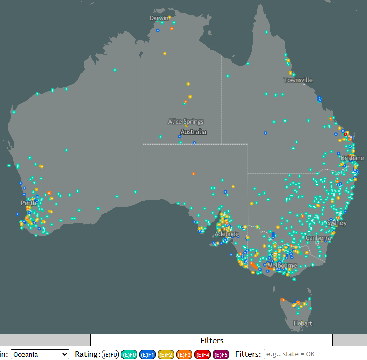
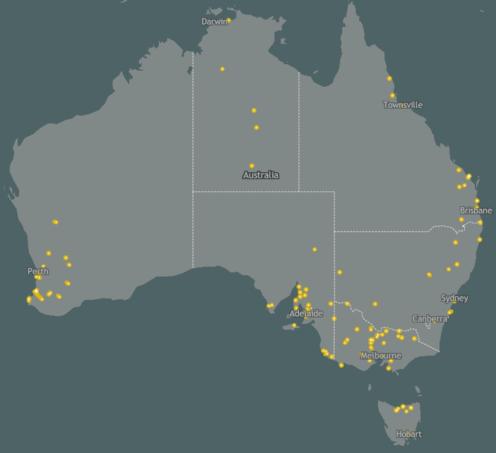
Australia sees approximately 30 to 80 Tornadoes a year however the true amount is likely more as most would go unreported, due to how isolated most would be. Most tornadoes are weak and short lived but a few notable tornadoes have occurred. For example an EF 3 Tornado on 1 July 1989 in Victoria traveled 70 kms. You can see that one on the map above, the long orange line in Western Victoria. On 7 July 1995 a EF 2 tornado near Bunbury, WA travelled 84kms, on 26 July 1961 a tornado tracked almost the same location of 80kms long.
Several Tornadoes have tracked close to Capital cities including one EF 2 tornado on 15 December 2015 in Kurnell, Just across the bay from Sydney Airport and an EF 0 near Canterbury, NSW on 21 October 2016. An EF 3 tornado killed 2 people in Brighton, Vic on 2 February 1918. In SEQ on 4 November 1973 a EF 3 Tornado unroofed homes and made several unsafe after a tornado tracked between Brookfield and Eight Mile Plains. 1 confirmed Tornado hit near the Perth suburbs of Dianella and Morley and another confirmed tornado near York on 7 June 2012, both EF 1’s. Over in Adelaide an EF 0 affected the suburb of Felixstow on 8 July 1998. An EF 0 went through Canberra on 28 January 1995. Risdon Vale near Hobart saw a EF 2 on 27 January 1971. In Darwin on 27 February 2001 tornadic type damage in Darwin’s northern suburbs of Fannie Bay, Ludmilla, Moil, Jingili, Wanguri, Leanyer and Karama, two paths 2 – 300 metres wide, EF 0 damage reported, this could have been a waterspout that came ashore.
This along with hundreds of other tornadoes have been reported over the years, yet many people still seem to think Australia doesn’t have tornadoes or the fact some nick name them Willy Willys, that means tornadoes don’t happen. Regardless of the nickname, the meteorological term is Tornado world wide. We may not see as many Tornadoes as the USA, but we are the 3rd most active continent after North America and Europe.
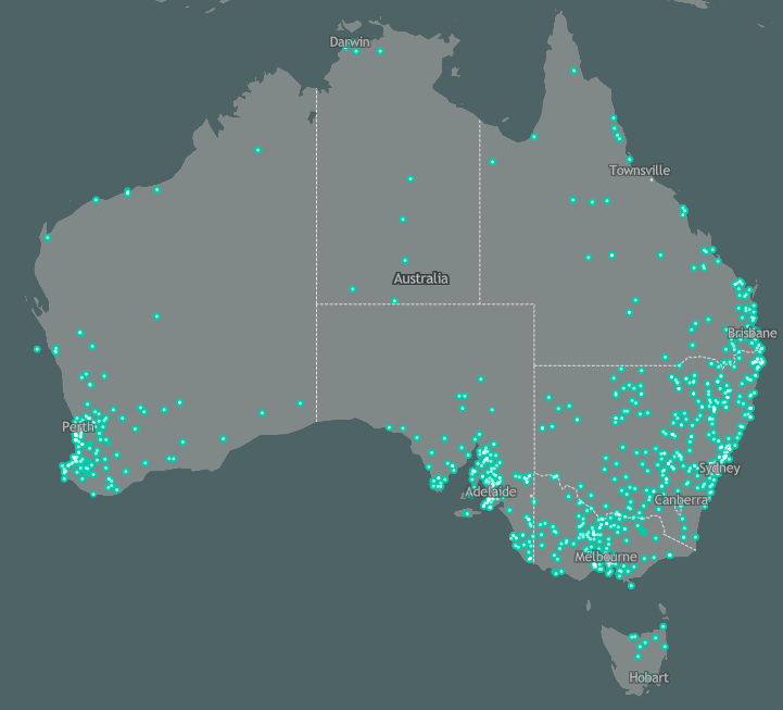
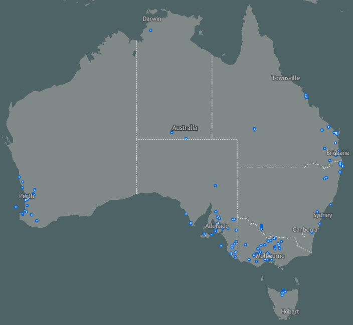
The following images are world wide Tornadoes, and maps filtered by EF ratings for Australia,


and Finally

2 Comments
Nicole Carbone
WOW! Super informative and easy to understand for the folks who do not have much knowledge about tornadoes. Love this Nikko!
Pat Ashby
Thank you. I loved it too.🌪So informative.