TC Alfred Update #22 (Valid as of 12:30am EST 5/3)
G’day everyone. Time for another update. But before I do. Alfreds current stats haven’t changed:-
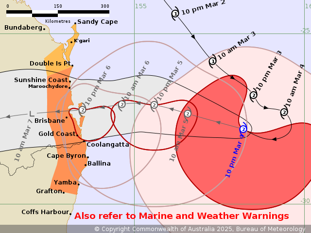
“Intensity: category 2, sustained winds near the centre of 95 kilometres per hour with wind gusts to 130 kilometres per hour.
Location: within 30 kilometres of 27.8 degrees South, 158.2 degrees East , 510 kilometres east of Brisbane and 480 kilometres east of Gold Coast .
Movement: west at 14 kilometres per hour.
Warning zone: Double Island Point in Queensland to Grafton in New South Wales, including Brisbane, Gold Coast, Sunshine Coast, Byron Bay and Ballina but not including Grafton.
Watch zone: Sandy Cape to Double Island Point in Queensland, including K’gari.”
Since intensifying to cat 2, Alfred has held his strength. Most models keeping him as a Cat 2 cyclone up until Landfall. While I don’t believe it will happen, I feel it’s my responsibility to mention it. Some guidance is suggesting a Cat 3 before landfall but this is a fairly low chance in my opinion but something to watch.
BoM and JTWC, the latter being one of the most accurate in the world, have the track just north of Brisbane, However the warning area stretches from Grafton to the Sunshine Coast. This warning area is for gale force winds within 24 hours. The worst will be on the southern part of the system. There will still be rain and wind on the north side but generally less severe.
Everyone should be prepared by now. Prepare for the worst, hope for the best. Is all you can do. He has made his turn to the west as of this arvo and is tracking in a general West direction towards the SE QLD coast. This track is expected to continue, it may go a little to the WNW or WSW but should continue mostly west. The area of the highest winds will likely condense as the system closes in on the coast and interacts with land.
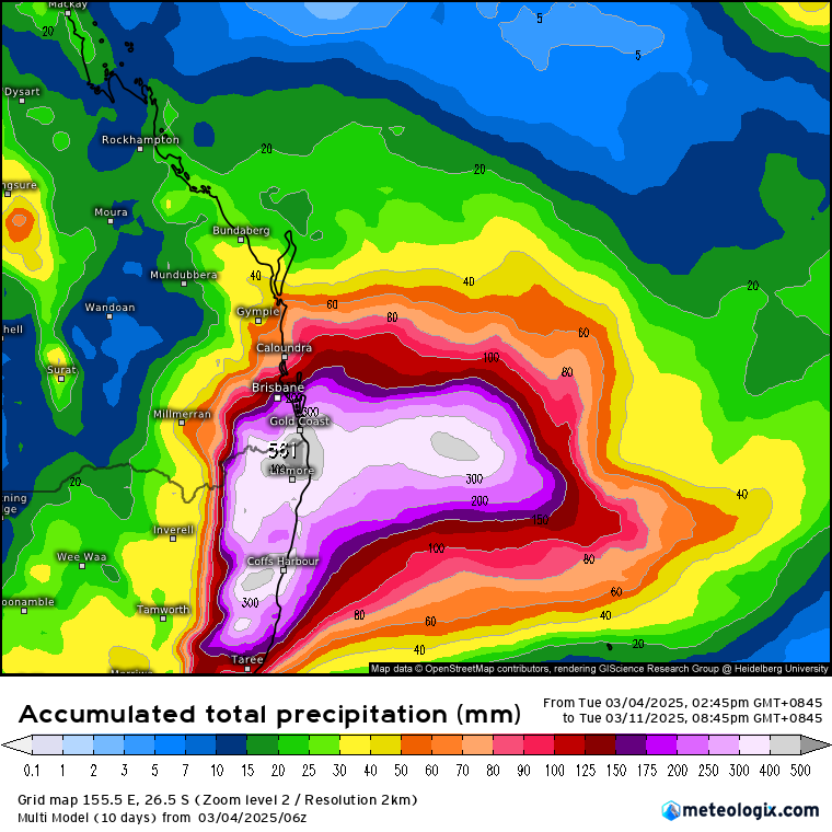
After landfall, the system will weaken rapidly however that will not be the end of the risk as the system as the systems rainfall will become more widespread, especially on the southern side as it draws in moisture from the coral sea. This will cause significant rainfall across SE QLD and NE NSW. 500 to 800 mm is possible across the region depending on the final track of Alfred.
I’ve had a fair amount of people ask me questions in comments but one that’s asked a lot is how far is the rain likely to go. That all depends on the systems final track. Rainfall outlooks have the majority of the rainfall east if the ranges. So my advice would be to keep up to date updates as issued.
Thanks