
TROPICAL CYCLONE FORECAST TRACK MAP
Severe Tropical Cyclone Zelia 18U
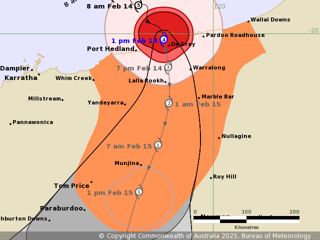
The forecast path shown above is the Bureau’s best estimate of the cyclone’s future movement and intensity. There is always some uncertainty associated with tropical cyclone forecasting and the grey zone indicates the range of likely tracks of the cyclone centre.
Due to the uncertainty in the future movement, the indicated winds will almost certainly extend to regions outside the rings on this map. The extent of the warning and watch zones reflects this.
This product is designed for land-based communities; mariners should read the coastal waters and high seas warnings.
Headline:
Severe Tropical Cyclone Zelia made landfall at 12:30pm near De Grey River mouth northeast of Port Hedland. Port Hedland to avoid the very destructive core of the cyclone.
Areas affected:
Warning zone: Wallal Downs to Whim Creek, including Port Hedland, and extending inland to Marble Bar, Nullagine, Tom Price and Paraburdoo .
Watch zone: None.
Cancelled zones: None.
Details of Severe Tropical Cyclone Zelia 18U at 1:00 pm AWST:
Intensity: category 4, sustained winds near the centre of 195 kilometres per hour with wind gusts to 270 kilometres per hour.
Location: within 20 kilometres of 20.1 degrees South, 119.1 degrees East , 55 kilometres east northeast of Port Hedland and 140 kilometres north northwest of Marble Bar .
Movement: southeast at 14 kilometres per hour .
Severe Tropical Cyclone Zelia (category 4) made landfall at 12:30pm near De Grey River mouth northeast of Port Hedland. Zelia will now take a general southerly track overland and weaken. Intense rainfall is expected near and to the east of the centre of the cyclone as it crosses the coast.
Hazards:
VERY DESTRUCTIVE WIND GUSTS of up to 270 kilometres per hour are likely within 30 kilometres of the centre of the cyclone but Port Hedland lies outside this region. Wind gusts near the centre will reduce this afternoon and tonight.
DESTRUCTIVE WIND GUSTS of up to 160 kilometres per hour are likely in coastal areas between Port Hedland and Pardoo this afternoon extending to inland areas near the track tonight.
Gales with DAMAGING WIND GUSTS to 120 kilometres per hour are occurring on the coast between Pardoo and Whim Creek, including Port Hedland. DAMAGING WIND GUSTS to 120 kilometres per hour should also extend to inland areas, possibly including Marble Bar, Nullagine, or Tom Price and Paraburdoo, on Saturday morning.
HEAVY to LOCALLY INTENSE RAINFALL which may lead to FLASH FLOODING is likely today across coastal and adjacent inland areas between Wallal Downs and Whim Creek, extending inland to Nullagine and Tom Price by early Saturday. Flood Watches and Warnings are also current for catchments in the Pilbara, western Kimberley and northern Gascoyne. Go to www.bom.gov.au/wa/warnings for further details.
There is no longer a risk of a storm tide at Port Hedland. Residents between De Grey and Wallal Downs are specifically warned of the potential of a DANGEROUS STORM TIDE in the next few hours. Tides are likely to rise significantly above the normal high tide mark with damaging waves and dangerous flooding of some low-lying areas close to the shoreline.
Recommended Action:
Ensure you know what to do in a cyclone. For the latest DFES community alerts and warnings visit www.emergency.wa.gov.au or download the Emergency WA app.
Details:
| Time (AWST) | Intensity Category | Latitude (decimal deg.) |
Longitude (decimal deg.) |
Estimated Position Accuracy (km) |
|
|---|---|---|---|---|---|
| 0hr | 1 pm February 14 | 4 | 20.1S | 119.1E | 20 |
| +6hr | 7 pm February 14 | 3 | 20.6S | 119.2E | 40 |
| +12hr | 1 am February 15 | 2 | 21.3S | 119.2E | 55 |
| +18hr | 7 am February 15 | 1 | 22.0S | 119.0E | 85 |
| +24hr | 1 pm February 15 | 1 | 22.9S | 118.7E | 115 |
| +36hr | 1 am February 16 | tropical low | 24.7S | 118.1E | 130 |
| +48hr | 1 pm February 16 | tropical low | 26.1S | 117.7E | 155 |
| +60hr | 1 am February 17 | tropical low | XXX | XXX | XXX |
| +72hr | 1 pm February 17 | tropical low | XXX | XXX | XXX |
Tropical Cyclone information is also available in MetEye