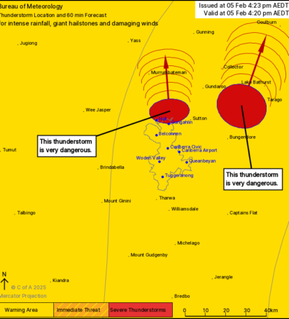
Severe Thunderstorm Warning
Issued by the Bureau of Meteorology
Date and Time: 05 February 2024, 4:23 PM AEDT
Valid Until: 05 February 2024, 5:20 PM AEDT
Location: Southeastern New South Wales, including regions around Hall, Gungahlin, Collector, and Lake Bathurst.
Warning Overview:
Severe thunderstorms are currently developing across the region, posing significant risks of intense rainfall, damaging winds, and large hailstones. These storms have been identified as very dangerous, with potential impacts on both safety and property.
Key Details:
– Thunderstorm Activity:
– Two areas of severe thunderstorms have been marked on the map, indicating immediate threats near Hall and Gungahlin, as well as near Collector and Lake Bathurst. The intensity of the storms suggests they could produce hazardous weather conditions.
– Rainfall:
– Expect intense rainfall in affected areas, which may lead to flash flooding. Be cautious of rapidly rising water levels in creeks and low-lying areas.
– Hail:
– Giant hailstones are possible, which can cause damage to vehicles, roofs, and crops. It is recommended to stay indoors and away from windows during the storm.
– Wind:
– Damaging winds are anticipated, with the potential for gusts that could exceed 90 km/h. Secure outdoor items and take precautions to protect yourself from flying debris.
Safety Advice:
– Seek shelter indoors, preferably in a sturdy building away from windows.
– Avoid travelling unless absolutely necessary. If you are on the road and encounter flooding or severe conditions, find a safe place to wait out the storm.
– Monitor local radio or weather updates for real-time information and further warnings.
Conclusion:
Residents in the affected areas should take this warning seriously. The thunderstorms are expected to be severe and potentially life-threatening. Stay vigilant and ensure your safety as conditions develop.
For further updates, please refer to the Bureau of Meteorology website or follow this site.