
TC Alfred Update #20 (Valid as of 12:30am EST)
After a brief intensity spike Monday morning, Alfred has maintained his strength fairly uniformly since becoming a Cat 1. Overnight and in to tomorrow morning, He is expected to begin slowing down and make the westerly turn back towards the Southern QLD coast. I have to admit it’s nice getting to the point where it’s not so uncertain anymore as to where he will go. Landfall is most likely between Brisbane and the Sunshine Coast, the uncertainty is timeframe, landfall could be somewhere between Thur night and Fri morning.
In the short term, Alfred is expected to intensify as he approaches the coast, becoming a Cat 2 as he makes landfall. A watch zone is current between Fraser coast and Grafton in NSW and the area immediately inland. This means gale force winds are expected within 24 to 48 hours. Rainfall should also increase across SE QLD and NE NSW in the same period as the system approaches the coast.
Rainfall is expected to become quite widespread and heavy once the system comes ashore. Widespread falls of 500 mm are possible with some areas potentially picking up higher amounts. Those in flood prone areas should be prepared, the Queensland emergency services should contact you via the 0444 444 444 service if they need to issue evacuation orders or other emergency alerts.
Have a good night and morning and follow The Wandering Weatherman for updates like this.
#cyclonealfred #weather #Queensland #seqld #nensw #tropicalcyclone #brisbane #suns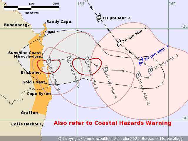 hinecoast