Thunderstorm and Tornado Outlook 15th May 2025 – USA
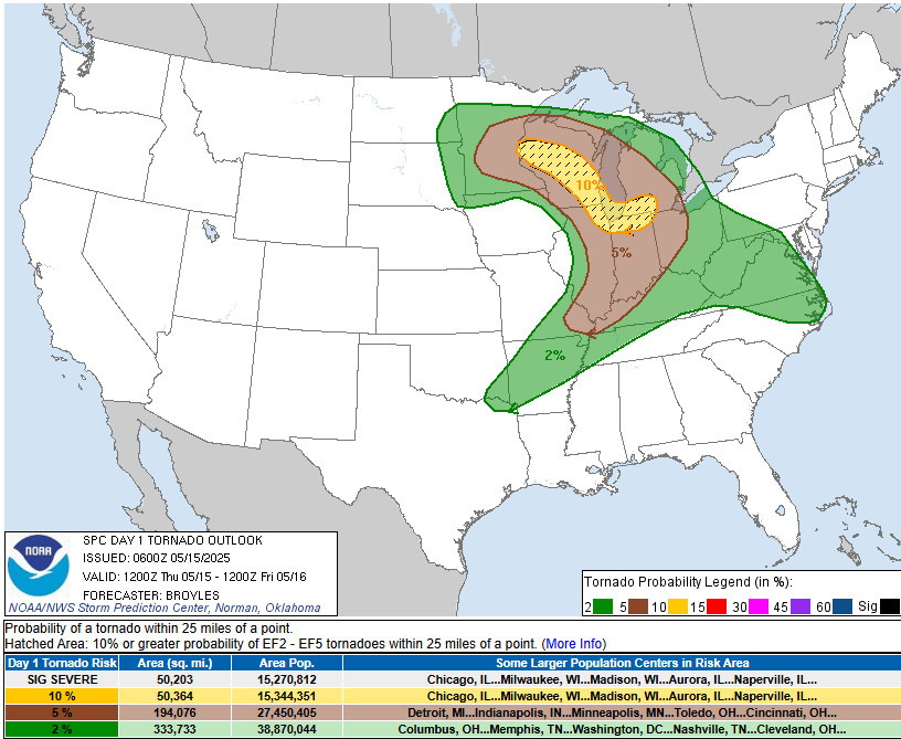
An Enhanced set up is predicted by the National Weather Service for Parts of the States of Minnesota, Wisconsin, Michigan, Illinois and Indiana. A slight chance is also possible over parts of Minnesota, Wisconsin, Michigan, Illinois, Indiana, Ohio, Virginia, Kentucky and the Far SE of Missouri. Elsewhere Marginal conditions are possible as indicated by the Green in the map below.
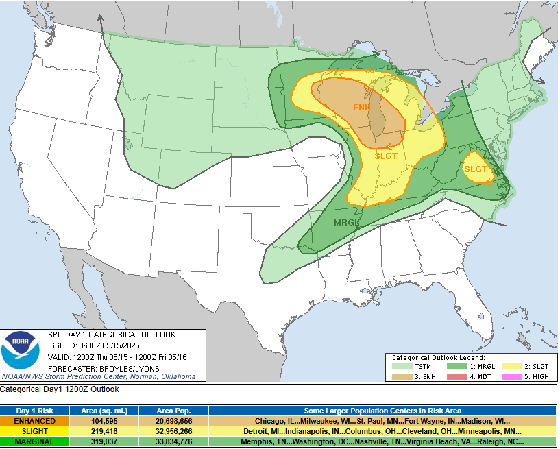
Here’s the official discussion from the NWS.
 SPC AC 150600

   Day 1 Convective Outlook
   NWS Storm Prediction Center Norman OK
   0100 AM CDT Thu May 15 2025

   Valid 151200Z - 161200Z

   ...THERE IS AN ENHANCED RISK OF SEVERE THUNDERSTORMS ACROSS PARTS OF
   EASTERN MINNESOTA...WISCONSIN...NORTHEAST ILLINOIS...NORTHERN
   INDIANA...SOUTHWEST AND SOUTHERN MICHIGAN...AND FAR NORTHWEST
   OHIO...

   ...THERE IS A SLIGHT RISK OF SEVERE THUNDERSTORMS ACROSS PARTS OF
   THE MID TO UPPER MISSISSIPPI VALLEY...GREAT LAKES...OHIO VALLEY AND
   MID-ATLANTIC...

   ...SUMMARY...
   Severe thunderstorms are expected across parts of the upper
   Mississippi River Valley and Great Lakes this afternoon and evening.
   Hailstones greater than 2 inches will be possible, along with
   tornadoes with a few that could be strong. Scattered wind damage
   will be likely, with wind gusts over 75 mph over parts of Lower
   Michigan and northern Indiana. Isolated severe thunderstorms are
   also expected through the lower Ohio River Valley, Ozarks and in
   parts of the Mid-Atlantic.

   ...Mid to Upper Mississippi Valley/Great Lakes/Ohio Valley...
   A negatively-tilted mid-level trough will move northeastward into
   the Upper Midwest today, as an associated jet streak translates
   eastward into the Ozarks. A secondary jet streak will move
   northeastward into the mid Missouri Valley. Strong large-scale
   ascent will overspread a broad moist sector from the Great Lakes
   into the Ohio Valley, resulting in a widespread severe weather event
   today.

   At the surface, a low will consolidate and move northward across the
   eastern Dakotas. A well defined warm front will advance northward
   into the Wisconsin, as a cold front moves eastward into the mid to
   upper Mississippi Valley. Ahead of the front, surface dewpoints from
   the mid 60s to the lower 70s F will result in moderate instability
   over much of the moist sector. Thunderstorms are first expected to
   initiate near the mid-level low over the upper Mississippi Valley,
   with storms developing south-southeastward along and ahead of the
   front during the afternoon.

   Indications suggest that the storms will remain somewhat spaced out,
   at least early in the event. The discrete nature of the convection,
   combined with moderate deep-layer shear, will be favorable for
   supercell development. A broken line of severe storms is expected to
   move east-northeastward into the vicinities of Milwaukee and Chicago
   late this afternoon. RAP forecast soundings at 21Z along the western
   shore of Lake Michigan have MLCAPE near 2000 J/kg, with 0-6 km shear
   of 35 to 40 knots, and 700-500 mb lapse rates near 7.5 C/km. This
   will be favorable for large hail and wind damage associated with
   supercells. The more intense supercells may produce hailstones
   greater than 2 inches in diameter. In addition, 0-3 km
   storm-relative helicity in the 250 to 300 m2/s2 will also support
   tornadoes, with the threat becoming maximized as supercells mature.
   A few strong tornadoes appear likely.

   Severe threat coverage will likely be maintained as a broken line
   segment gradually organizes. A transition to linear mode appears
   likely by early evening. Supercells and rotating elements within the
   line should be capable of producing tornadoes. Wind damage will also
   be likely along the leading edge of the line, with gusts over 75 mph
   possible from western Lower Michigan southward into northern
   Indiana. A potential for hailstones greater than 2 inches in
   diameter will continue during the early evening with supercells
   embedded within the line.

   Further south into the lower Ohio Valley, storm coverage will be a
   bit more isolated. However, cells that can develop within the
   strongly unstable airmass will likely become supercells with large
   hail and severe gusts. A tornado threat is also expected. It appears
   that a corridor of greater severe threat will develop somewhere near
   the Ohio River during the late afternoon, which could be dependent
   upon the distribution and magnitude of instability.

   ...Ozarks/Ark-La-Tex...
   Southwest mid-level flow will be in place today across the Ozarks
   and Ark-La-Tex, as a jet streak moves eastward into the region. A
   moist airmass will be in place to the southeast of the jet, where
   surface dewpoints will be in the upper 60s and lower 70s F. By
   afternoon, much of this airmass will be moderately unstable.
   However, large-scale ascent to the south of the jet is forecast to
   remain relatively weak, which should keep convective development
   isolated. Any cell that can initiate despite a capping inversion
   could become severe and have a large hail and wind-damage threat.
   The threat could persist from late afternoon into the early evening.


   ....Central Appalachians/Mid-Atlantic...
   A mid-level ridge will move eastward into the central Appalachians
   today, as northwesterly flow remains to the east of the Appalachian
   crest. At the surface, a moist airmass will be in place along much
   of the southern and central Atlantic Seaboard. Surface dewpoints in
   the 60s F will likely result in moderate instability by afternoon.
   Although large-scale ascent will be weak, topographic forcing and
   increasing low-level convergence could aid convective initiation as
   surface temperatures warm up. Short-term model solutions suggest the
   greatest convective potential will be across eastern Virginia, where
   low-level flow is forecast to increase during the day. This,
   combined with moderate deep-layer shear and steep low-level lapse
   rates, may be enough for an isolated severe threat. Severe wind
   gusts and large hail will be possible with supercells or short
   intense line segments.

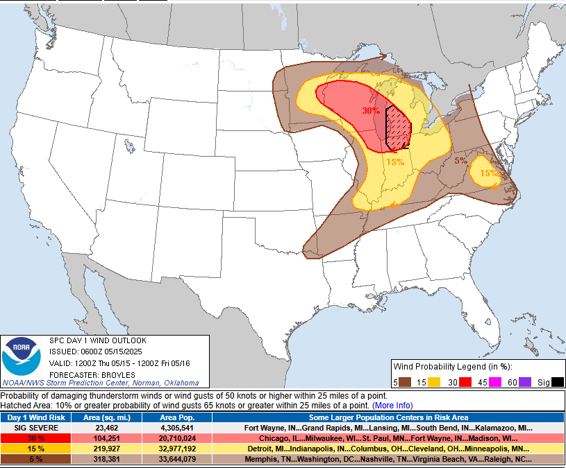
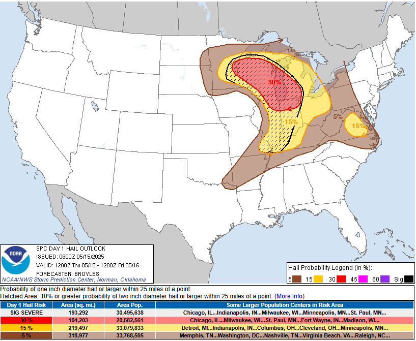
Below are the individual outlooks for Tornadoes, Wind and Hail